
On September 4th, Waatavaran invited three visionary architects and urban planners of Mumbai – Rahul Kadri of IMK Architects, Pranav Naik of Studio Pomegranate, and Shilpa Chandawarkar, a professor at the Indian Education Society’s College of Architecture – to initiate a dialogue on Mumbai’s Green Recovery. With them, we invited young architecture and planning students to share their ideas on sustainable development for Mumbai. The event began by addressing the environmental issues caused by the crazy race for development. What followed was a lively discussion on how young students can use their skills to make the city greener, more equitable, and more resilient.
We are delighted to present the vision of some of these young Mumbaikar’s in a series of articles, that attempt to drive design, policies and governance towards an equitable and just environment.
Let’s hear more about Avinash’s vision for building a better Mumbai!
Adaptive methods for coastal communities to prepare for sea-level rise: The case of Vashi Gaothan
Mumbai, a city with a population of more than 22 million, a coastline of 270 kms of Arabian sea and an additional 200 sq.km. under the coastal regulation zone is undoubtedly exposed to the vulnerabilities of sea-level rise due to climate change.
This vulnerability exaggerates due to an ever increasing demand for land for housing, commercial and industrial needs which has impacted the natural and ecologically sensitive areas, causing depletion to their existence. Moreover, overexploitation of these coastal lands due to spilling industrial effluents in the creek, garbage and construction debris dumping into these ecologically sensitive areas, land grabbing by destructing mangroves place our ecological weapons against climatic hazards i.e. the mangroves and wetlands, under threat. Increased rainfall and flooding in the cities are also causing the existing infrastructure in place to crumble making more and more people vulnerable to this devastation.
Since the city’s inception, there have been negotiations that take place between choosing ecology and land development at different levels in the city. Where the decision makers/policy makers at a higher-level and the coastal communities and slums are at the receiving end. This leads to continuous conflicts between the urban built environment and urban ecological environments where ecology has been losing the battle. With such immense pressure on the ecological environments and biodiversity, climate change is also pacing towards these cities at a faster rate. By 2100, the sea level will rise by 1m all over the world. This article thus echoes on how cities have to become adaptable to this climate change and maintain an ecological balance with land development, built environment while also addressing the vulnerabilities of the communities.
Urban flooding in coastal regions of Navi Mumbai:
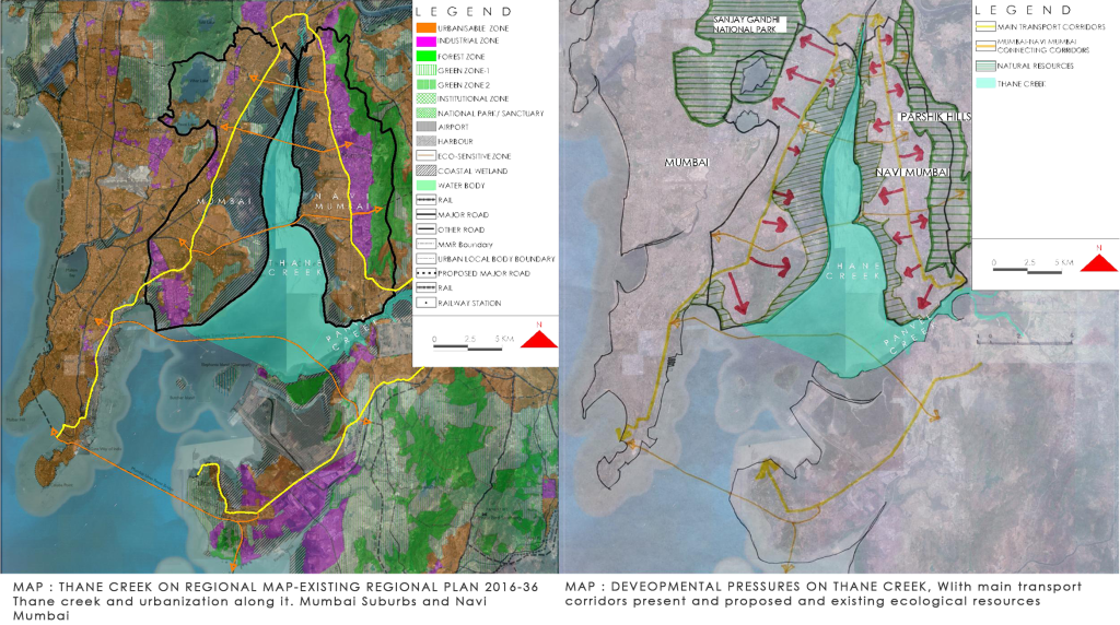
Loss of land and infrastructure, vulnerability of communities to such change, lack of economic strength in the communities to recover from such disasters, loss of biodiversity and uneven distribution of these shall be the deal breakers. To understand this, the negotiations between the land and ecology and furthermore estimated its future with the climate change and effects on rising sea level in the region. For which, this article undertook the example of Thane Creek and the development of the planned city of Navi Mumbai. This included studying all the factors involved in its development from 1973 when the first development plan of the city was published up to today.

The article highlights how land development for Navi Mumbai required reclamation, where a node like Vashi, required more than 50% of its area reclaimed. It undertook widening of existing estuaries and using them as storm water drain connected from the Parshik Hill to the holding ponds. This helped absorb excess water towards the creek edge to avoid flooding. While this method of reclamation was chosen to prevent flooding like in the case of Mumbai but today, the city of Navi Mumbai floods every year. Despite the holding ponds being situated at a higher level to avoid creek water to enter, the age-old capacities of drains (60mm per hour) and holding pond capacity of 8 hours are unable to prevent flooding. Moreover, there is a decline in mangrove cover of the coastal area due to industrial effluents from the Thane-Belapur belt, and the city is now sensing the after effects of urbanization. While the city was designed for the ‘100-year flood’ which meant that there is only 1% chance of flooding to happen in a year, but with climate change and sea-level rise the idea of ‘100-year flood’ is far left off.
My Vision for Mumbai’s Green Recovery:
In order to overcome this, a planning approach of land and water integration is required where land use zoning and flood plain zoning along with water resource management will help reduce the damage. Likewise, treating flood water and rising sea level as a part of the water cycle of storm water drain and wastewater systems, by designing lands and spaces which are ‘meant to fail’ or ‘safe to fail’ will prevent any life and monetary losses during heavy rains.

All these should be integrated at multiple scales in the city using public spaces, open spaces, swales, stormwater and drainage systems as flood adaptive spaces that work with natural systems for development of resilient water based-urban systems. Also, instead of using rigid methods like floodwalls and levees to protect the coast from damage we need to use ecologically adaptive ways. Therefore, this article reiterates on using water as a re-integrative, permeable member of the urban form. While also considering design of movement through space-time via circulation, dynamism and flexibility, along with combinations of work, leisure and commerce activities, ultimately supporting the communities.

